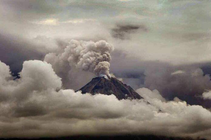
Indonesia’s Mount Semeru unleashed a rapid string of eruptions in just 13 hours, sending ash up to 900 meters above the summit and prompting strict hazard warnings.
Story Snapshot
- Officials logged nine to ten eruptions from shortly after midnight to early afternoon local time.
- Ash columns rose 300 to 900 meters above the summit, confirming sustained activity.
- Monitors reported measurable seismic signals tied to key blasts.
- Authorities kept exclusion zones to guard against deadly flows and falling rocks.
What Authorities Reported About The Eruption Count
Indonesia’s volcano monitors tracked a burst of activity at Mount Semeru from after midnight through early afternoon on October 13. A national wire service listed nine eruptions through late morning, naming times starting at 12:09 a.m. and running to 10:37 a.m.. A separate outlet counted at least ten when adding a 1:11 p.m. event, framing the window as about 13 hours. The differing totals reflect different cutoffs, not a dispute over the activity.
Reporters linked to monitoring data described five early events before dawn, more mid-morning bursts, and a final early afternoon eruption. The timeline places Semeru’s strongest morning blast at 10:37 a.m., followed by another at 1:11 p.m. The agencies did not publish a full event log in these stories, but the clock times, plume heights, and hazard posture all align on a day of repeated ash-producing eruptions.
How High The Ash Rose And What Instruments Detected
Observers reported ash columns reaching as high as 900 meters above the summit, with other plumes in the 300 to 600 meter range. Monitors tied several eruptions to measured shaking. One early afternoon burst produced a seismic signal with a maximum amplitude of 15 millimeters and lasted 88 seconds, while the 10:37 a.m. event reached 22 millimeters and lasted 137 seconds. These measurements show the blasts were not just visual reports; instruments also picked them up.
Winds can shift ash quickly, but the coverage did not include verified ashfall amounts in towns that day. The reports focused on column heights and signal strength, which help track how often and how forcefully the volcano is venting. Those metrics matter because even a short, lower plume can warn of unstable material near the crater that can fail with little notice, especially if rain falls on fresh ash.
Why Exclusion Zones Stayed In Place
Indonesia’s Center for Volcanology and Geological Hazard Mitigation kept Semeru at Level Three, which is the second-highest on the local four-step scale, and told people to avoid the Besuk Kobokan River channel for 13 kilometers because of pyroclastic-flow and mudflow dangers. Separate reports described a five-kilometer “no-go” zone around the crater to avoid hot rocks and other ejecta. These rules aim to keep residents and workers out of paths where fast, hot flows can race downhill.
🌋 Volcanic Ash Advisory: Semeru
Mount Semeru, Indonesia: eruption reported at 14:46 UTC on 8 October 2026. Ash reached 15,000 feet and was moving east at 5 knots. Advisory issued at 18:20 UTC; ground reports indicate ongoing eruptions.More info: https://t.co/oFT17RBMZe
— Early Warning (@VolcanoEWS) October 8, 2026
Semeru is among the world’s most active volcanoes, with near-constant activity recorded for decades. That background means a day of many small eruptions can seem routine until a dome collapse or heavy rain turns loose material into deadly flows. In December 2021, an eruption and collapse sent hot clouds and ash far from the summit and caused heavy damage and many deaths, a reminder of how quickly risk can change.
What We Know And What We Do Not
The October 13 reports establish a clear run of eruptions, confirmed ash columns up to 900 meters, and instrumented signals for key events. They also show a firm hazard posture with defined exclusion zones. The coverage does not document injuries, evacuations, or property damage that day, and it does not include the full agency event table to reconcile whether the count should be nine or ten under official rules. The safety guidance stands either way.
Why This Matters To Readers Far From Java
Natural hazards test trust in public warnings. People across the spectrum worry that distant officials can seem slow in crisis yet heavy-handed in routine times. Semeru’s case shows why precise, shared data matters. Clear times, heights, and rules help locals decide when to move and when to wait. It also shows why steady investment in monitoring beats headline drama and why enforcing known danger zones can save lives when the next big collapse comes.
Sources:
insiderpaper.com, megapolitan.antaranews.com, malaymail.com, databoks.katadata.co.id, jatim.antaranews.com, link.springer.com